 Coaching Centre
Monitoring and predicting hazards
How scientists monitor earthquakes, volcanoes and tsunamis with seismometers, GPS, satellites, gas sensors and DART buoys, why earthquakes can be forecast but not predicted, how tsunami warnings work in Australia, and how engineering reduces the impact of earthquakes.
On 26 December 2004 a magnitude 9.1 earthquake off Sumatra set off a tsunami that killed about 228 000 people in 14 countries. There was no warning system in the Indian Ocean, and waves reached Sri Lanka and Thailand up to two hours later. Ten-year-old Tilly Smith, on holiday in Thailand, saw the sea draining away, remembered a geography lesson about tsunamis, and warned her parents. The beach was cleared before the waves arrived.
Hazard or disaster?
A natural hazard is an event, such as an earthquake or eruption, that could harm people. It becomes a disaster when it seriously affects a community that can't cope. The same size earthquake can kill thousands in one place and nobody in another, depending on how many people live nearby, how buildings are made, and whether there is warning. Science can't stop earthquakes, but it can reduce the risk.
The tools of monitoring
| Technology | What it measures | Used for |
|---|---|---|
| Seismometer | Ground vibration | Locating earthquakes; detecting the small swarms of earthquakes as magma moves under a volcano |
| GPS stations | Position, to a few millimetres | Plate movement; strain building up on faults; ground swelling as magma collects |
| Satellite radar (InSAR) | Changes in ground height over large areas | Mapping how far the ground moved in an earthquake; volcanoes inflating |
| Tiltmeter | Tiny changes in the slope of the ground | Volcanoes swelling before an eruption |
| Gas sensors | Sulfur dioxide and carbon dioxide from vents | Fresh magma rising towards the surface |
| Sonar and magnetometers on ships | Depth and magnetism of the sea floor | Mapping ridges, trenches and magnetic stripes |
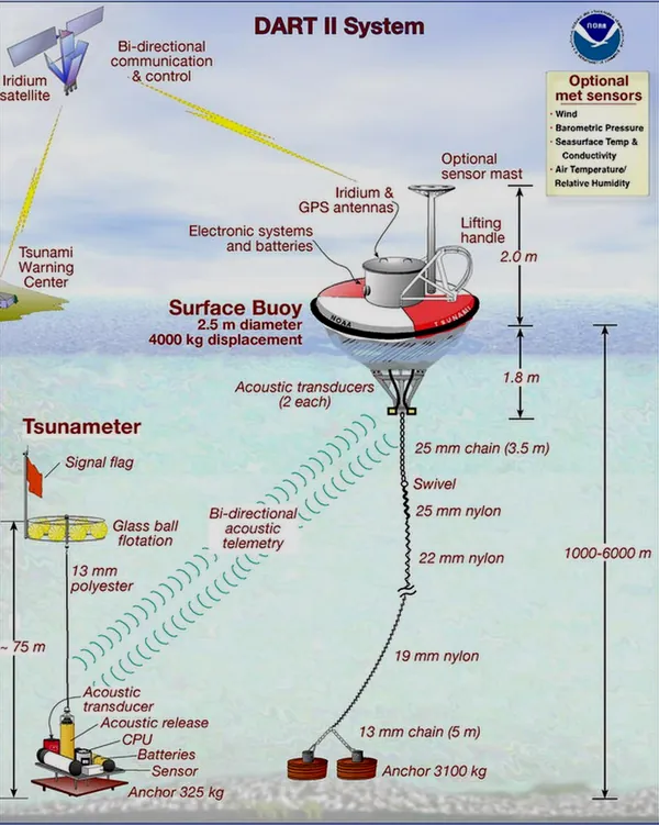
| DART buoys | Changes in sea level over the deep ocean | Confirming that a tsunami is travelling |
Predicting earthquakes
No one can predict an earthquake, meaning say exactly when, where and how big it will be. Scientists can forecast earthquakes as probabilities. By measuring how fast a fault is loaded (from GPS), and digging trenches across the fault to date past earthquakes, they can estimate the chances over decades. For example, the Alpine Fault in New Zealand has about a 75% chance of a large earthquake in the next 50 years. Forecasts guide building codes and emergency planning.
Some countries, including Japan, Mexico and the USA, have earthquake early warning systems. Seismometers near the fault detect the fast P waves and send an alert by phone, TV and radio before the slower, more damaging S and surface waves arrive. The warning is only seconds to a minute long, but it is enough to stop high-speed trains, open fire station doors, and let people take cover. During the 2011 Tōhoku earthquake, all Japan's bullet trains stopped safely.
Forecasting eruptions
Volcanoes usually give warning signs as magma rises: swarms of small earthquakes, the ground swelling, and more gas. In 1991 scientists monitoring Mt Pinatubo in the Philippines saw all three and persuaded authorities to evacuate tens of thousands of people. The eruption was the second-largest of the 20th century, but evacuations saved an estimated 5000 or more lives. Warnings are not always enough. In 2019 the alert level at Whakaari / White Island in New Zealand had been raised, but tours continued, and a sudden steam-driven eruption killed 22 people.
Tsunami warnings
A tsunami is a series of waves caused when a large volume of water is suddenly moved, most often by an undersea earthquake that lifts the sea floor at a subduction zone. Landslides and eruptions, like Hunga Tonga in 2022, can also cause them.
In the deep ocean a tsunami travels at the speed of a jet plane but may be less than a metre high, so ships barely notice it. Its speed depends on the depth of the water: speed = √(9.8 × depth), in metres per second. As it reaches shallow water it slows down, the back of the wave catches up, and it can grow to tens of metres high. In 2011 the Tōhoku tsunami ran up to about 40 m above sea level on the Japanese coast.
After 2004, Australia set up the Joint Australian Tsunami Warning Centre (JATWC), run by the Bureau of Meteorology and Geoscience Australia, which has operated since 2007. When a large undersea earthquake happens, it:
- uses seismometers to find the location and magnitude within minutes
- models how a tsunami would travel and which coasts are at risk
- checks sea-level data from DART buoys (a pressure sensor on the deep sea floor sends readings to a buoy and then by satellite) and coastal tide gauges
- issues warnings to emergency services and the public, by coastline, with expected arrival times.
Natural warnings are just as important. If you are at the coast and feel strong shaking that lasts a long time, or see the sea suddenly drain away or hear a loud roar from the ocean, go to high ground straight away. Don't wait for an official warning.
- Send a wave from the Java Trench to Broome. How long do people in Broome have to reach high ground?
- Which route gives the least warning time? Which gives the most?
- For which route is most of the time spent crossing the deep ocean? For which is it spent in the shallow water near the coast?
- Switch to Depth and speed. Find the depth at which a tsunami travels about as fast as a car on a highway (100 km/h).
Building for earthquakes
Earthquakes rarely kill people directly; collapsing buildings do. Engineers reduce the risk by:
- Building codes that set how strong buildings must be in each area. Australia's earthquake code was strengthened after the 1989 Newcastle earthquake.
- Base isolation: the building sits on rubber-and-steel bearings that let the ground move underneath while the building moves much less. The Te Papa museum and Parliament House in Wellington stand on base isolators.
- Cross-bracing and steel-reinforced concrete that let buildings bend without breaking. Unreinforced brick buildings are the most dangerous; many of the people killed in Newcastle and Christchurch were hit by falling masonry.
- Dampers, such as the giant 660-tonne pendulum in the Taipei 101 skyscraper, which reduce swaying.
- Planning: avoiding building on soft, wet ground that shakes more and can turn to liquid (liquefaction), and placing hospitals and schools on safer sites.
Test yourself
Earthquake early warning systems work because
The alert races ahead of the slower waves.
A tsunami travels fastest in
Speed = √(9.8 × depth).
Which is a sign that magma may be rising under a volcano?
These were the warnings before Pinatubo in 1991.
Base isolation protects a building by
Flexible bearings absorb the shaking.
Label the tsunami.
Put the steps of a tsunami warning in order.
Scientists can earthquakes as probabilities but cannot say exactly when they will happen. Satellite measures how the ground moves. A is a series of waves caused when water is suddenly moved. It slows down and grows taller in water. A becomes a disaster when a community can't cope.
The 2004 Indian Ocean tsunami killed about 228 000 people. Explain how scientific understanding and technology have been used since then to reduce the risk to people in Australia from tsunamis.
After 2004, the Joint Australian Tsunami Warning Centre was set up by the Bureau of Meteorology and Geoscience Australia and has operated since 2007. When a large undersea earthquake happens, seismometers around the world record it and the centre calculates its location and magnitude within minutes. Because scientists understand that a tsunami's speed depends on the depth of the ocean, computer models can estimate which coasts are at risk and when the waves will arrive; for example, a tsunami from the Java Trench would take about four hours to reach Broome. DART buoys, which use a pressure sensor on the sea floor to detect a change in water height, and coastal tide gauges confirm whether a tsunami has formed, so false alarms are reduced. Warnings are then sent to emergency services and the public. Education about natural warning signs, such as the sea drawing back, also helps people act quickly.