 Coaching Centre
The evidence for plate tectonics
How the theory of plate tectonics grew from Wegener's continental drift and Hess's sea-floor spreading, the fossil, rock and glacier evidence for Gondwana, magnetic stripes and sea-floor ages, and how a rejected idea became accepted science.
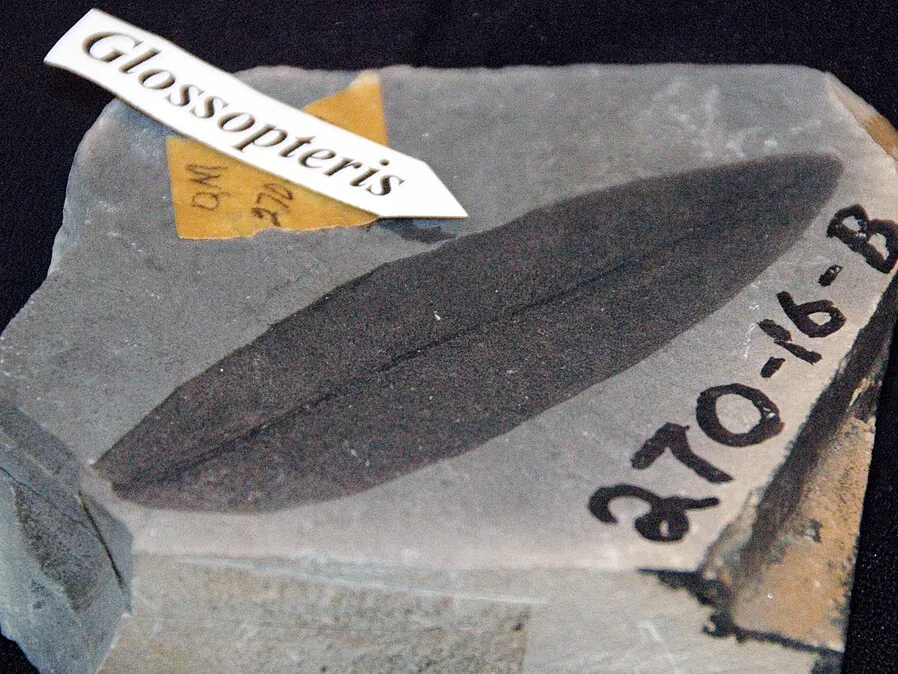
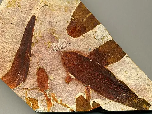
The black coal mined near Newcastle and Lithgow is full of fossil leaves of a plant called Glossopteris. Exactly the same leaves turn up in the coal of India, South Africa, Brazil and, strangest of all, Antarctica, where nothing like it could grow today. In 1912 one scientist thought he knew why. It took the rest of the world about fifty years to agree with him.
Wegener's continental drift
In 1912 the German scientist Alfred Wegener proposed that the continents had once been joined in a single supercontinent, Pangaea, and had slowly drifted apart. He called this continental drift. Today we know Pangaea came together about 335 million years ago and began breaking up about 200 million years ago. Its southern part, Gondwana, held South America, Africa, Madagascar, India, Antarctica, Australia and Zealandia.
Wegener gathered evidence from several different sciences:
- The fit of the continents. The coastlines of South America and Africa look like puzzle pieces. In 1965 the British geophysicist Edward Bullard used a computer to show the fit is even better along the edges of the continental shelves, about 1 km under the sea, which is where the continents really end.
- Fossils. Land plants and animals that could not cross oceans are found on continents now thousands of kilometres apart. The seed fern Glossopteris is found on every southern continent. The freshwater reptile Mesosaurus is found only in southern Africa and Brazil. Lystrosaurus, a pig-sized reptile, was found in Antarctica in 1969, matching finds in Africa and India.
- Rocks and mountains. Rock layers and old mountain belts on one side of the Atlantic continue on the other side when the continents are put back together.
- Ancient climates. About 300 million years ago an ice sheet covered parts of southern Africa, South America, India and Australia. The scratches it left in the rock point in directions that only make sense if those lands were joined around the South Pole. Meanwhile coal, which forms in warm swamps, is found in Antarctica.
- Fit all six pieces together. Which two continents are the easiest to match, and why?
- Turn on Mesosaurus. Why is a freshwater reptile better evidence than a fish that lived in the sea?
- Turn on the glacier scratches with the pieces scattered, then rebuilt. What do the arrows show only when Gondwana is together?
- Which piece of evidence do you think is the most convincing? Explain your choice.
Why the idea was rejected
Most geologists, especially in Europe and North America, rejected continental drift. The main reason was that Wegener couldn't explain how whole continents could plough through the solid ocean floor. His suggested forces, linked to the Earth's spin and the pull of the Moon, were shown to be far too weak. His own measurements also suggested that Greenland was moving more than 10 metres a year, which was wildly wrong and made critics more doubtful. In the late 1920s the British geologist Arthur Holmes suggested that slow convection currents in the mantle could carry the continents, but there was no direct evidence yet. Wegener died on an expedition in Greenland in 1930.
Evidence from the sea floor
The breakthrough came from the oceans, using technology developed during and after the Second World War.
- Mapping the ridges. Ships used echo sounding (sonar) to measure the depth of the ocean: a sound pulse is sent down and the time for its echo to return gives the depth. In the 1950s the American geologist and cartographer Marie Tharp, working with Bruce Heezen, turned thousands of these depth readings into the first detailed maps of the ocean floor. She spotted a deep valley running along the centre of the Mid-Atlantic Ridge: a crack where the sea floor was being pulled apart. Ridges like it run through every ocean, about 65 000 km in total.
- Sea-floor spreading. In 1962 the American geologist Harry Hess proposed that new sea floor forms at the ridges as magma rises and cools, then moves slowly away on each side, and that old sea floor sinks back into the mantle at deep ocean trenches.
- Magnetic stripes. When lava cools, magnetic minerals in it line up with the Earth's magnetic field, like tiny compass needles frozen in place. The Earth's field reverses direction every few hundred thousand years. In 1963 Fred Vine and Drummond Matthews (and, separately, Lawrence Morley) showed that the sea floor has stripes of normal and reversed magnetism that are mirror images on either side of a ridge. That is exactly what sea-floor spreading predicts.
- Rock ages. From 1968 the drilling ship Glomar Challenger collected rock from the sea floor. The rock is youngest at the ridges and gets older with distance from them. No sea floor anywhere is older than about 180 million years, while tiny mineral grains in Western Australia's Jack Hills are 4.4 billion years old. The ocean floor is constantly recycled.
A magnetic reversal that happened 2.6 million years ago is recorded in rock 78 km from the centre of a ridge. How fast is the sea floor moving away from the ridge?
speed = 78 km ÷ 2.6 million years = 30 km per million years.
30 km = 3 000 000 cm, so 3 000 000 cm ÷ 1 000 000 years = 3 cm a year. (Handy shortcut: km per million years = mm per year, so 30 km/Myr = 30 mm/yr.)
The other side moves away at the same rate, so the ocean widens by about 6 cm a year. That is a little faster than your fingernails grow.
By the late 1960s continental drift and sea-floor spreading had been combined into one theory: plate tectonics. The Earth's rigid outer shell is broken into plates that carry both continents and ocean floor. Today GPS receivers measure the movement directly, to within a millimetre (5F). Plate tectonics is a good example of how science works: an idea was proposed, rejected for lack of a mechanism, then revived and changed when new technology produced new evidence.
Test yourself
The main reason most geologists rejected continental drift was that
Without a mechanism, the evidence was not enough to convince most scientists.
Why is Mesosaurus good evidence that South America and Africa were joined?
A freshwater animal could not swim across salty ocean.
Rock on the sea floor is youngest
New crust forms at ridges and moves away.
A reversal 1 million years old is found 25 km from a ridge. The spreading rate on that side is
25 km per million years = 25 mm a year = 2.5 cm a year.
Name each piece of evidence.
Put these steps in the development of plate tectonics in order.
Wegener called the supercontinent . Its southern part, which included Australia, was . Ships measured the depth of the ocean by echo . Hess's idea that new ocean floor forms at ridges is called sea-floor . Stripes of normal and magnetism are mirror images on each side of a ridge.
Explain how evidence from the ocean floor changed scientists' views of continental drift between 1912 and the late 1960s.
Wegener's evidence (fit, fossils, rocks and ancient glaciers) suggested the continents had moved, but he could not explain what force could move them through the ocean floor, so most geologists rejected the idea. In the 1950s echo sounding let Marie Tharp and Bruce Heezen map the ocean floor, revealing mid-ocean ridges with a rift valley along their centre, suggesting the floor was being pulled apart. In 1962 Harry Hess proposed sea-floor spreading: magma rises at the ridges to form new crust, which moves away on both sides and sinks back into the mantle at trenches. Magnetic surveys then showed stripes of normal and reversed magnetism that are mirror images on each side of the ridges, exactly what would happen if new rock forms at the ridge and records each reversal as it spreads. Drilling showed rock gets older away from the ridges and that no sea floor is older than about 180 million years. This provided a mechanism: continents are not ploughing through the ocean floor but are carried on moving plates. By the late 1960s this became the theory of plate tectonics.